
Make a donation
Gear up for your next adventure:
As an Amazon Associate, this site earns from qualifying purchases at no extra cost to you.
El Caraño topographic map
Click on the map to display elevation.
Make a donation
Gear up for your next adventure:
As an Amazon Associate, this site earns from qualifying purchases at no extra cost to you.
About this map
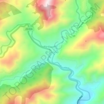
Name: El Caraño topographic map, elevation, terrain.
Location: El Caraño, Florencia, Caquetá, RAP Amazonía, Colombia (1.71251 -75.66384 1.75251 -75.62384)
Average elevation: 740 m
Minimum elevation: 451 m
Maximum elevation: 1,167 m
Make a donation
Gear up for your next adventure:
As an Amazon Associate, this site earns from qualifying purchases at no extra cost to you.
Other topographic maps
Click on a map to view its topography, its elevation and its terrain.
Perímetro Urbano Florencia
Colombia > Caquetá > Florencia
La cabecera municipal homónima es una ciudad joven, punto de convergencia de los municipios del norte y del sur del Caquetá. Está ubicada en la zona de piedemonte entre la Cordillera Oriental y la Amazonia, en la margen derecha del río Hacha, lo cual le da una posición privilegiada ambientalmente al ser…
Average elevation: 337 m