
Korahe topographic map
Interactive map
Click on the map to display elevation.
About this map
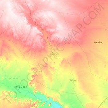
Name: Korahe topographic map, elevation, terrain.
Location: Korahe, Somali, Éthiopie (5.69398 43.33467 7.70697 45.84848)
Average elevation: 620 m
Minimum elevation: 229 m
Maximum elevation: 1,122 m
Other topographic maps
Click on a map to view its topography, its elevation and its terrain.
Iimeey Bari
Éthiopie > Somali > Iimeey Bari
Iimeey Bari, Shabelle, Somali, Éthiopie
Average elevation: 375 m
Harerge Kifle Hager
Harerge Kifle Hager, Shinile, Somali, Éthiopie
Average elevation: 1,541 m