Geolocate

Los Angeles topographic map

Click on the map to display elevation.

About this map

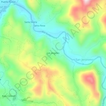
Name: Los Angeles topographic map, elevation, terrain.

Location: Los Angeles, San Jeronimo, Pangoa, Satipo, Junín, Perú (-11.41100 -74.47766 -11.37100 -74.43766)

Average elevation: 763 m

Minimum elevation: 593 m

Maximum elevation: 1,054 m

Gear up for your next adventure:

🥾Hiking Shoes - Durable and comfortable shoes for trail hiking
🧥Thermal Layer - Insulating layer for cold outdoor conditions
Backpacking Tent - Lightweight tent for long-distance hiking trips
🥾Light Hiking Boots - Lightweight and comfortable boots for day hikes
👟Sport Hiking Sandals - Breathable footwear for water crossings and camp rest

As an Amazon Associate, this site earns from qualifying purchases at no extra cost to you.