
Make a donation
Gear up for your next adventure:
As an Amazon Associate, this site earns from qualifying purchases at no extra cost to you.
Schildow topographic map
Click on the map to display elevation.
Make a donation
Gear up for your next adventure:
As an Amazon Associate, this site earns from qualifying purchases at no extra cost to you.
Schildow
Die nächstgelegene Eisenbahnstation ist der Haltepunkt Mühlenbeck-Mönchmühle der Berliner S-Bahn im Nachbarortsteil Mühlenbeck. Der zentral gelegene Bahnhof Schildow an der „Heidekrautbahn“ hat keinen regelmäßigen Personenverkehr. In Höhe des Bahnübergangs der Mühlenbecker Straße Schillerstraße befand sich der Haltepunkt Schildow-Mönchmühle an der Heidekrautbahn. Dieser wurde zwischenzeitlich abgetragen. Nach Plänen der Niederbarnimer Eisenbahn soll die Station in Schildow sowie die in Mühlenbeck mit der neuen Heidekrautbahn (RB27) wieder errichtet werden.
Make a donation
Gear up for your next adventure:
As an Amazon Associate, this site earns from qualifying purchases at no extra cost to you.
About this map
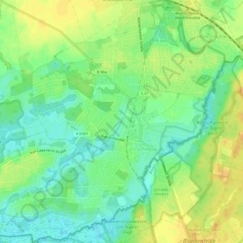
Name: Schildow topographic map, elevation, terrain.
Average elevation: 44 m
Minimum elevation: 30 m
Maximum elevation: 58 m
Make a donation
Gear up for your next adventure:
As an Amazon Associate, this site earns from qualifying purchases at no extra cost to you.
Other topographic maps
Click on a map to view its topography, its elevation and its terrain.
Make a donation
Gear up for your next adventure:
As an Amazon Associate, this site earns from qualifying purchases at no extra cost to you.