Geolocate

Colli topographic map

Click on the map to display elevation.

About this map

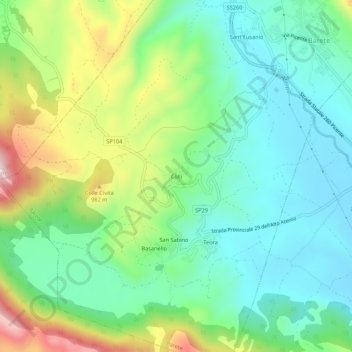
Name: Colli topographic map, elevation, terrain.

Location: Colli, Barete, L'Aquila, Abruzzo, 67012, Italy (42.41305 13.24004 42.45305 13.28004)

Average elevation: 837 m

Minimum elevation: 696 m

Maximum elevation: 1,149 m

Gear up for your next adventure:

🧥Softshell Hiking Jacket - The perfect balance of wind protection and breathability
🥾Lightweight Hiking Boots - Boots for comfort and mobility on long hikes
🧊Insulated Water Bottle - Keeps drinks cold in summer and prevents freezing in winter
🛶Waterproof Dry Bags - Keep electronics and clothes dry during river crossings
Camping Essentials - All-in-one gear for a comfortable camping trip

As an Amazon Associate, this site earns from qualifying purchases at no extra cost to you.