Geolocate

Bempflingen topographic map

Click on the map to display elevation.

About this map

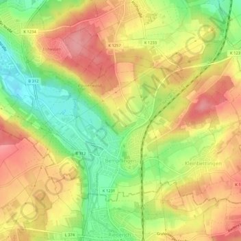
Name: Bempflingen topographic map, elevation, terrain.

Location: Bempflingen, GVV Neckartenzlingen, Landkreis Esslingen, Baden-Württemberg, 72658, Germany (48.56514 9.25002 48.58912 9.30211)

Average elevation: 349 m

Minimum elevation: 292 m

Maximum elevation: 393 m

Other topographic maps

Click on a map to view its topography, its elevation and its terrain.

Gear up for your next adventure:

Camping Tent - Weather-resistant tents suitable for 2 to 6 people
🧴Waterproofing Spray - Restore the DWR coating on jackets and tents
🥾Approach Shoes - Shoes designed for climbing approaches and rugged trails
Lightweight Backpacking Tent - Compact tent for efficient hiking trips
💧Collapsible Water Bottle - Space-saving water bottle for outdoor activities

As an Amazon Associate, this site earns from qualifying purchases at no extra cost to you.