Geolocate

Curdi topographic map

Click on the map to display elevation.

About this map

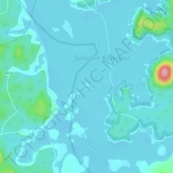
Name: Curdi topographic map, elevation, terrain.

Location: Curdi, Sanguem, South Goa, Goa, India (15.14506 74.16674 15.18506 74.20674)

Average elevation: 49 m

Minimum elevation: 35 m

Maximum elevation: 176 m

Other topographic maps

Click on a map to view its topography, its elevation and its terrain.

Salaulim Dam

India > Goa > Sanguem > Sanguem

Average elevation: 39 m

Maulinguem

India > Goa > Sanguem

Average elevation: 101 m

Sanvordem

India > Goa > Sanguem

Average elevation: 28 m

Gear up for your next adventure:

🧴Insect Repellent - Protect yourself from bugs during outdoor adventures
🧥Softshell Jacket - Windproof and breathable jacket for hiking
🎒Backpack Rain Cover - External shield to keep your entire pack dry
🧢Sun Protection Cap - Breathable cap to protect from sun exposure
🥾Mountain Hiking Boots - High-traction boots for rocky terrain

As an Amazon Associate, this site earns from qualifying purchases at no extra cost to you.