Geolocate

Miaria topographic map

Click on the map to display elevation.

About this map

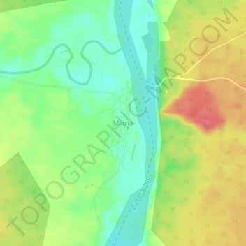
Name: Miaria topographic map, elevation, terrain.

Location: Miaria, Megantoni, La Convención, Cusco, Perú (-11.32267 -73.01723 -11.28267 -72.97723)

Average elevation: 306 m

Minimum elevation: 276 m

Maximum elevation: 341 m

Gear up for your next adventure:

🎒Backpack Rain Cover - External shield to keep your entire pack dry
🥾Light Trekking Boots - Supportive boots for multi-day treks
📷Outdoor Action Camera - Capture high-elevation views and rugged adventures
🦶Hiking Shoe Insoles - Added support for high arches and long days on feet
Camping Tent - Weather-resistant tents suitable for 2 to 6 people

As an Amazon Associate, this site earns from qualifying purchases at no extra cost to you.