Geolocate

Stevens Peak topographic map

Click on the map to display elevation.

About this map

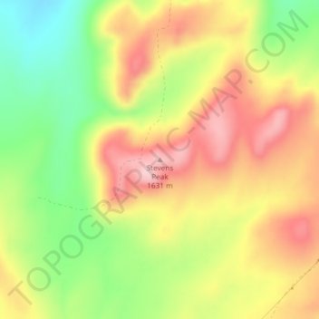
Name: Stevens Peak topographic map, elevation, terrain.

Location: Stevens Peak, Bingham County, Idaho, United States (43.13598 -112.29475 43.13608 -112.29465)

Average elevation: 1,522 m

Minimum elevation: 1,412 m

Maximum elevation: 1,622 m

Other topographic maps

Click on a map to view its topography, its elevation and its terrain.

Blackfoot

United States > Idaho > Bingham County

Average elevation: 1,371 m

Blackfoot

United States > Idaho > Bingham County

Average elevation: 1,371 m

Gear up for your next adventure:

🚲Handlebar Phone Mount - View topographic-map.com live while cycling
🧶550 Survival Paracord - Versatile utility cord for emergency repairs and rigging
🔦LED Flashlight - Powerful and long-lasting flashlight for camping and emergencies
🧴Bear Spray Holster - Quick-access carry for essential Canadian wilderness safety
🥾Hiking Gaiters - Protect legs and shoes from mud, snow, and debris

As an Amazon Associate, this site earns from qualifying purchases at no extra cost to you.