
Make a donation
Gear up for your next adventure:
As an Amazon Associate, this site earns from qualifying purchases at no extra cost to you.
Mayenne topographic map
Click on the map to display elevation.
Make a donation
Gear up for your next adventure:
As an Amazon Associate, this site earns from qualifying purchases at no extra cost to you.
Mayenne
The department is varied in topography. Much of it is largely flat, but there are also hilly areas, some with steep-sided valleys and ravines. Of the total area of 516,189 hectares (1,275,532 acres), some 354,000 hectares (875,000 acres) are arable, 69,000 hectares (170,000 acres) are grassland, 26,000 hectares (65,000 acres) are forests and woodland and 50,000 acres (20,200 ha) are heathland and moorland. To the north lies the Armorican Massif, a plateau that has been eroded over time, the highest summit of which, the Mont des Avaloirs, is the highest point in the department at 417 m (1,368 ft) above sea level. A branch range to the south of this plateau forms the ridge that divides the Mayenne Valley from the Vilaine Valley.
Make a donation
Gear up for your next adventure:
As an Amazon Associate, this site earns from qualifying purchases at no extra cost to you.
About this map
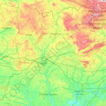
Name: Mayenne topographic map, elevation, terrain.
Location: Mayenne, Pays de la Loire, Metropolitan France, France (47.73382 -1.23885 48.56829 -0.04902)
Average elevation: 129 m
Minimum elevation: 20 m
Maximum elevation: 413 m
Make a donation
Gear up for your next adventure:
As an Amazon Associate, this site earns from qualifying purchases at no extra cost to you.