
Make a donation
Gear up for your next adventure:
As an Amazon Associate, this site earns from qualifying purchases at no extra cost to you.
Ain topographic map
Click on the map to display elevation.
Make a donation
Gear up for your next adventure:
As an Amazon Associate, this site earns from qualifying purchases at no extra cost to you.
Ain
Ain is a department of geographic contrasts. In the north, the plain of Bresse is bordered by the river Saône and rises slightly towards the north-east. In the south-east, the territory of Dombes has more than a thousand ponds and lakes. In the east, the mountain chain of the southern Jura overlooks the plain of Bresse. The busy transport axes to Italy and Switzerland crisscross the valleys. The Gex region is separated from the rest of the department by the last eastern mountain chain of the Jura where the highest elevation in the department, the Crêt de la Neige (1720 m), can be found. Gex belongs geographically to the Lake Geneva basin.
Make a donation
Gear up for your next adventure:
As an Amazon Associate, this site earns from qualifying purchases at no extra cost to you.
About this map
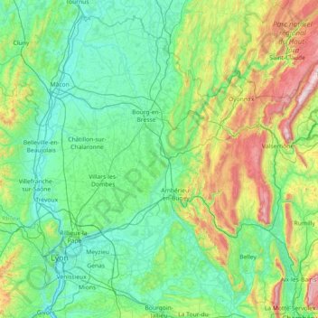
Name: Ain topographic map, elevation, terrain.
Location: Ain, Auvergne-Rhône-Alpes, Metropolitan France, France (45.61076 4.72817 46.51990 6.17003)
Average elevation: 418 m
Minimum elevation: 151 m
Maximum elevation: 1,697 m
Make a donation
Gear up for your next adventure:
As an Amazon Associate, this site earns from qualifying purchases at no extra cost to you.