Geolocate

Stanton topographic map

Click on the map to display elevation.

About this map
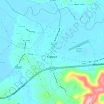
Name: Stanton topographic map, elevation, terrain.

Location: Stanton, Powell County, Kentucky, United States (37.83285 -83.87717 37.86195 -83.82824)

Average elevation: 215 m

Minimum elevation: 189 m

Maximum elevation: 384 m

Other topographic maps

Click on a map to view its topography, its elevation and its terrain.

Natural Bridge

United States > Kentucky > Powell County

Average elevation: 314 m

Slade

United States > Kentucky > Powell County

Average elevation: 311 m

Vaughns Mill

United States > Kentucky > Powell County

Average elevation: 220 m

Slade

United States > Kentucky > Powell County

Average elevation: 311 m

Gray's Arch

United States > Kentucky > Powell County

Average elevation: 330 m

Gear up for your next adventure:

🧥Fleece Jacket - Warm and lightweight jacket for layering
🪜Heavy Duty Carabiners - Multi-use clips for securing gear to your backpack
💡LED Camping Lantern - Illuminate your campsite with long-lasting lanterns
🚲Heavy Duty Bike Lock - Secure your bike at the trailhead or during stops
🕶️Polarized Sunglasses - Protect your eyes with durable polarized lenses

As an Amazon Associate, this site earns from qualifying purchases at no extra cost to you.