Geolocate

Palma Alta topographic map

Click on the map to display elevation.

About this map

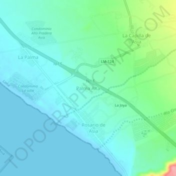
Name: Palma Alta topographic map, elevation, terrain.

Location: Palma Alta, Asia, Cañete, Lima, Perú (-12.81028 -76.58833 -12.77028 -76.54833)

Average elevation: 22 m

Minimum elevation: -1 m

Maximum elevation: 111 m

Other topographic maps

Click on a map to view its topography, its elevation and its terrain.

Lomas de Asia Sector B

Perú > Lima > Asia

Average elevation: 399 m

Gear up for your next adventure:

🏃Hydration Running Vest - Carry water and maps close to your body for speed
🥾Waterproof Trail Shoes - Shoes designed to handle wet terrain
🛰️Satellite Messenger - Emergency communication for areas with no cell service
🥾Waterproof Hiking Shoes - Durable shoes for wet and rugged trails
🧦Merino Wool Socks - Moisture-wicking comfort for long-distance hiking

As an Amazon Associate, this site earns from qualifying purchases at no extra cost to you.