
Make a donation
Gear up for your next adventure:
As an Amazon Associate, this site earns from qualifying purchases at no extra cost to you.
Montesinho topographic map
Click on the map to display elevation.
Make a donation
Gear up for your next adventure:
As an Amazon Associate, this site earns from qualifying purchases at no extra cost to you.
About this map
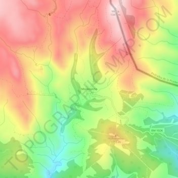
Name: Montesinho topographic map, elevation, terrain.
Location: Montesinho, França, Bragança, Distrito de Bragança, Portugal (41.91917 -6.78509 41.95917 -6.74509)
Average elevation: 1,090 m
Minimum elevation: 814 m
Maximum elevation: 1,334 m
Make a donation
Gear up for your next adventure:
As an Amazon Associate, this site earns from qualifying purchases at no extra cost to you.
Other topographic maps
Click on a map to view its topography, its elevation and its terrain.
Barragem de Serra Serrada
Portugal > Distrito de Bragança > Bragança > França
Average elevation: 1,261 m
Barragem de Serra Serrada
Portugal > Distrito de Bragança > Bragança > França
Average elevation: 1,261 m