
Make a donation
Gear up for your next adventure:
As an Amazon Associate, this site earns from qualifying purchases at no extra cost to you.
Gučevo topographic map
Click on the map to display elevation.
Make a donation
Gear up for your next adventure:
As an Amazon Associate, this site earns from qualifying purchases at no extra cost to you.
Gučevo
Gučevo (Serbian Cyrillic: Гучево, pronounced [ɡûːtʃeʋo]) is a mountain in western Serbia, near the town of Loznica, overlooking the Drina river and Banja Koviljača. Its highest peak Crni vrh has an elevation of 779 meters above sea level.
Make a donation
Gear up for your next adventure:
As an Amazon Associate, this site earns from qualifying purchases at no extra cost to you.
About this map
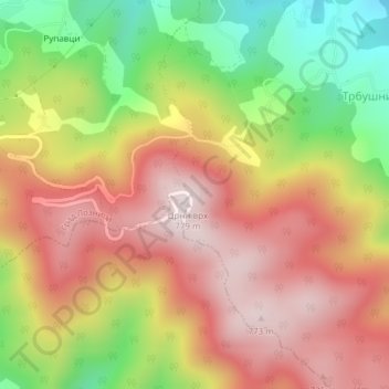
Name: Gučevo topographic map, elevation, terrain.
Average elevation: 526 m
Minimum elevation: 214 m
Maximum elevation: 772 m
Make a donation
Gear up for your next adventure:
As an Amazon Associate, this site earns from qualifying purchases at no extra cost to you.