
Make a donation
Gear up for your next adventure:
As an Amazon Associate, this site earns from qualifying purchases at no extra cost to you.
Heilsberg topographic map
Click on the map to display elevation.
Make a donation
Gear up for your next adventure:
As an Amazon Associate, this site earns from qualifying purchases at no extra cost to you.
Heilsberg
Heilsberg liegt unweit nördlich der Landesstraße 1060 von Rudolstadt nach Weimar entfernt. Nachbarorte sind: Eschdorf, Remda, Kirchremda und Milbitz bei Teichel. Der kleine Landkessel wird nördlich von bewaldeten Anhöhen bei Breitenheerda und Tännich und im Süden von den bewaldeten Anhöhen, die von Eschdorf bis Rudolstadt reichen, begrenzt. Geologisch handelt es sich überwiegend um grundwasserferne Muschelkalkverwitterungsböden.
Make a donation
Gear up for your next adventure:
As an Amazon Associate, this site earns from qualifying purchases at no extra cost to you.
About this map
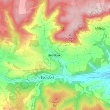
Name: Heilsberg topographic map, elevation, terrain.
Average elevation: 384 m
Minimum elevation: 255 m
Maximum elevation: 523 m
Make a donation
Gear up for your next adventure:
As an Amazon Associate, this site earns from qualifying purchases at no extra cost to you.
Other topographic maps
Click on a map to view its topography, its elevation and its terrain.
Kanu Wandern auf der Saale
Deutschland > Thüringen > Landkreis Saalfeld-Rudolstadt > Rudolstadt > Oberpreilipp
Average elevation: 229 m