
Make a donation
Gear up for your next adventure:
As an Amazon Associate, this site earns from qualifying purchases at no extra cost to you.
Kaaterskill Falls topographic map
Click on the map to display elevation.
Make a donation
Gear up for your next adventure:
As an Amazon Associate, this site earns from qualifying purchases at no extra cost to you.
About this map
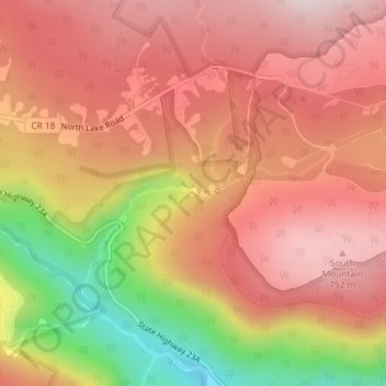
Name: Kaaterskill Falls topographic map, elevation, terrain.
Average elevation: 610 m
Minimum elevation: 303 m
Maximum elevation: 781 m
Make a donation
Gear up for your next adventure:
As an Amazon Associate, this site earns from qualifying purchases at no extra cost to you.
Other topographic maps
Click on a map to view its topography, its elevation and its terrain.
Sleepy Hollow Lake
United States > New York > Greene County > Sleepy Hollow Lake
Average elevation: 28 m
Town of Halcott
United States > New York > Greene County
The pass between Bearpen and neighboring Vly Mountain is traversed by Halcott Mountain Road, an unimproved county highway which reaches 2,800 feet (850 m) at the col, making it the highest elevation free public through road in New York State. It is also the only route between Halcott and the rest of Greene…
Average elevation: 720 m
Make a donation
Gear up for your next adventure:
As an Amazon Associate, this site earns from qualifying purchases at no extra cost to you.
Four Corners Unit
United States > New York > Greene County > Town of Prattsville
Average elevation: 570 m
Make a donation
Gear up for your next adventure:
As an Amazon Associate, this site earns from qualifying purchases at no extra cost to you.
Vosburgh Swamp Wildlife Management Area
United States > New York > Greene County > Town of Coxsackie
Average elevation: 16 m
Catskill Forest Preserve Detatched Parcel
United States > New York > Greene County > Town of Catskill
Average elevation: 65 m
Make a donation
Gear up for your next adventure:
As an Amazon Associate, this site earns from qualifying purchases at no extra cost to you.
Make a donation
Gear up for your next adventure:
As an Amazon Associate, this site earns from qualifying purchases at no extra cost to you.
Malden West Camp Fire District Map
United States > New York > Greene County > Saugerties
Average elevation: 49 m
Middle Ground Flats
United States > New York > Greene County > Village of Athens
Average elevation: 11 m
Make a donation
Gear up for your next adventure:
As an Amazon Associate, this site earns from qualifying purchases at no extra cost to you.