
Make a donation
Gear up for your next adventure:
As an Amazon Associate, this site earns from qualifying purchases at no extra cost to you.
High Flats topographic map
Click on the map to display elevation.
Make a donation
Gear up for your next adventure:
As an Amazon Associate, this site earns from qualifying purchases at no extra cost to you.
About this map
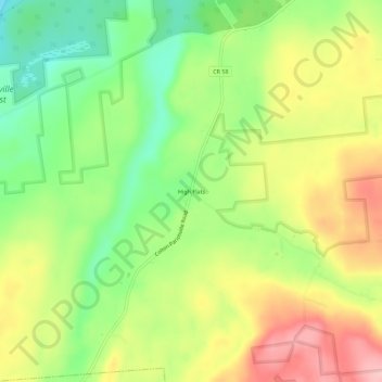
Name: High Flats topographic map, elevation, terrain.
Average elevation: 284 m
Minimum elevation: 209 m
Maximum elevation: 369 m
Make a donation
Gear up for your next adventure:
As an Amazon Associate, this site earns from qualifying purchases at no extra cost to you.
Other topographic maps
Click on a map to view its topography, its elevation and its terrain.
Higley Flow State Park
United States > New York > Saint Lawrence County > Town of Colton
Average elevation: 296 m
Cranberry Lake
United States > New York > Saint Lawrence County
Cranberry Lake is located at 44°13′21″N 074°50′11″W / 44.22250°N 74.83639°W / 44.22250; -74.83639 (44.2225615, -74.8362986) and its elevation is 1,489 feet (454 m).
Average elevation: 479 m
Make a donation
Gear up for your next adventure:
As an Amazon Associate, this site earns from qualifying purchases at no extra cost to you.
Make a donation
Gear up for your next adventure:
As an Amazon Associate, this site earns from qualifying purchases at no extra cost to you.
Cranberry Lake
United States > New York > Saint Lawrence County
Cranberry Lake is located at 44°13′21″N 074°50′11″W / 44.22250°N 74.83639°W / 44.22250; -74.83639 (44.2225615, -74.8362986) and its elevation is 1,489 feet (454 m).
Average elevation: 487 m
Make a donation
Gear up for your next adventure:
As an Amazon Associate, this site earns from qualifying purchases at no extra cost to you.
Make a donation
Gear up for your next adventure:
As an Amazon Associate, this site earns from qualifying purchases at no extra cost to you.