Geolocate

Saint Peters topographic map

Click on the map to display elevation.

About this map

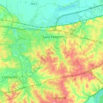
Name: Saint Peters topographic map, elevation, terrain.

Location: Saint Peters, Saint Charles County, Missouri, 63376, United States (38.72134 -90.67641 38.83080 -90.54921)

Average elevation: 155 m

Minimum elevation: 125 m

Maximum elevation: 198 m

Other topographic maps

Click on a map to view its topography, its elevation and its terrain.

Defiance

United States > Missouri > Saint Charles County

Average elevation: 153 m

Hamburg

United States > Missouri > Saint Charles County

Average elevation: 164 m

Gear up for your next adventure:

🧭GPS Handheld Device - Reliable GPS navigation for outdoor adventures
🛰️Satellite Messenger - Emergency communication for areas with no cell service
🧶550 Survival Paracord - Versatile utility cord for emergency repairs and rigging
🥾Trekking Poles - Adjustable trekking poles to reduce knee stress and improve stability
💡Portable Camping Lamp - Rechargeable lamp for campsite lighting

As an Amazon Associate, this site earns from qualifying purchases at no extra cost to you.