Geolocate

Evandale topographic map

Click on the map to display elevation.

About this map

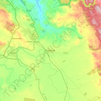
Name: Evandale topographic map, elevation, terrain.

Location: Evandale, Northern Midlands, Tasmania, 7212, Australia (-41.62544 147.20417 -41.51224 147.41519)

Average elevation: 173 m

Minimum elevation: 19 m

Maximum elevation: 407 m

Other topographic maps

Click on a map to view its topography, its elevation and its terrain.

Frog Hill

Australia > Tasmania

Average elevation: 875 m

Mount Kate

Australia > Tasmania

Average elevation: 995 m

Tasman Peninsula

Australia > Tasmania > Tasman > Fortescue

Average elevation: 167 m

Mount Jukes

Australia > Tasmania

Average elevation: 773 m

Ulverstone

Australia > Tasmania > Ulverstone

Average elevation: 37 m

Bullock Hill

Australia > Tasmania > Grove

Average elevation: 147 m

Highland Waters

Australia > Tasmania > London Lakes

Average elevation: 759 m

Stillwater Hill

Australia > Tasmania

Average elevation: 353 m

Legges Tor

Australia > Tasmania

Average elevation: 1,457 m

Rowlands Hill

Australia > Tasmania

Average elevation: 388 m

Recherche Bay

Australia > Tasmania

Average elevation: 10 m

Bastyan Dam

Australia > Tasmania > Tullah

Average elevation: 233 m

Gear up for your next adventure:

🥾Mountaineering Boots - Supportive boots for climbing and high-altitude hiking
Lightweight Camping Tent - Portable shelter optimized for Canadian backcountry camping
🌬️Windproof Camp Stove - Efficient cooking even on exposed mountain peaks
🧦Crew Hiking Socks - Comfortable socks for long-distance hikes
🦶Hiking Shoe Insoles - Added support for high arches and long days on feet

As an Amazon Associate, this site earns from qualifying purchases at no extra cost to you.