
Make a donation
Gear up for your next adventure:
As an Amazon Associate, this site earns from qualifying purchases at no extra cost to you.
Horba topographic map
Click on the map to display elevation.
Make a donation
Gear up for your next adventure:
As an Amazon Associate, this site earns from qualifying purchases at no extra cost to you.
About this map
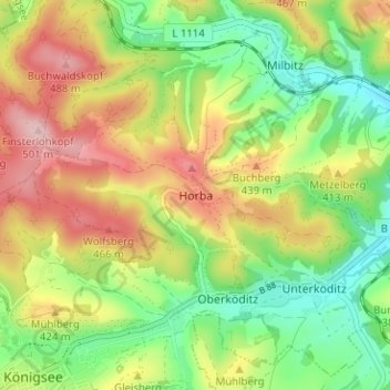
Name: Horba topographic map, elevation, terrain.
Average elevation: 382 m
Minimum elevation: 288 m
Maximum elevation: 501 m
Make a donation
Gear up for your next adventure:
As an Amazon Associate, this site earns from qualifying purchases at no extra cost to you.
Other topographic maps
Click on a map to view its topography, its elevation and its terrain.
Oberhain
Deutschland > Thüringen > Landkreis Saalfeld-Rudolstadt > Königsee
Oberhain und seine Ortsteile liegen auf einer waldarmen Hochfläche zwischen dem Schwarzatal im Süden und dem Rinnetal im Norden. Oberhain liegt am Hädderbach, der westlich an der 665 Meter hohen Barigauer Höhe entspringt und östlich des Ortes in die Schwarza mündet.
Average elevation: 512 m
Paulinzella
Deutschland > Thüringen > Landkreis Saalfeld-Rudolstadt > Königsee
Average elevation: 425 m
Make a donation
Gear up for your next adventure:
As an Amazon Associate, this site earns from qualifying purchases at no extra cost to you.
Solsdorf
Deutschland > Thüringen > Landkreis Saalfeld-Rudolstadt > Königsee
Solsdorf liegt am Nordrand des Thüringer Waldes in einer Höhe von 370 m über NN.
Average elevation: 417 m
Königsee
Deutschland > Thüringen > Landkreis Saalfeld-Rudolstadt > Königsee
Königsee liegt an der nordwestlichen Grenze des Landkreises, in einer Höhe von 377 m ü. NHN.
Average elevation: 461 m