
Thank you for supporting this site ❤️
Make a donation
Make a donation
Gear up for your next adventure:
As an Amazon Associate, this site earns from qualifying purchases at no extra cost to you.
Colosía topographic map
Click on the map to display elevation.
Thank you for supporting this site ❤️
Make a donation
Make a donation
Gear up for your next adventure:
As an Amazon Associate, this site earns from qualifying purchases at no extra cost to you.
About this map
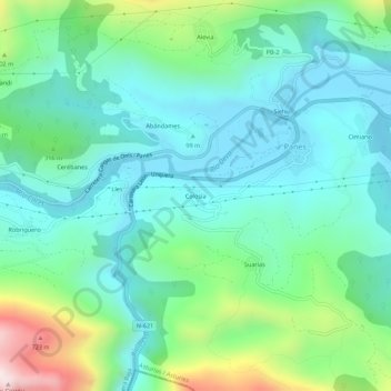
Name: Colosía topographic map, elevation, terrain.
Location: Colosía, Panes, Peñamellera Baja, Asturien, 33570, Spanien (43.29837 -4.61799 43.33837 -4.57799)
Average elevation: 214 m
Minimum elevation: 13 m
Maximum elevation: 846 m
Thank you for supporting this site ❤️
Make a donation
Make a donation
Gear up for your next adventure:
As an Amazon Associate, this site earns from qualifying purchases at no extra cost to you.