
Make a donation
Gear up for your next adventure:
As an Amazon Associate, this site earns from qualifying purchases at no extra cost to you.
Provincia de Copiapó topographic map
Click on the map to display elevation.
Make a donation
Gear up for your next adventure:
As an Amazon Associate, this site earns from qualifying purchases at no extra cost to you.
About this map
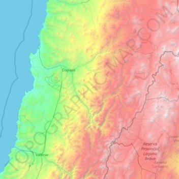
Name: Provincia de Copiapó topographic map, elevation, terrain.
Location: Provincia de Copiapó, Región de Atacama, Chile (-28.64263 -71.14235 -26.64312 -68.26321)
Average elevation: 2,274 m
Minimum elevation: 0 m
Maximum elevation: 6,765 m
Make a donation
Gear up for your next adventure:
As an Amazon Associate, this site earns from qualifying purchases at no extra cost to you.
Other topographic maps
Click on a map to view its topography, its elevation and its terrain.
Caleta Chañaral de Aceituno
Chile > Región de Atacama > Provincia de Huasco > Freirina
Average elevation: 10 m
Carretera Panamericana Sur
Chile > Región de Atacama > Provincia de Huasco > Vallenar
Average elevation: 433 m
San Félix
Chile > Región de Atacama > Provincia de Huasco > Alto del Carmen
Average elevation: 1,546 m
Las Marquesas
Chile > Región de Atacama > Provincia de Huasco > Alto del Carmen
Average elevation: 1,418 m
Make a donation
Gear up for your next adventure:
As an Amazon Associate, this site earns from qualifying purchases at no extra cost to you.
Sierra Nevada de Lagunas Bravas
Chile > Región de Atacama > Provincia de Chañaral > Diego de Almagro
Average elevation: 5,878 m
Los Loros
Chile > Región de Atacama > Provincia de Copiapó > Tierra Amarilla
Average elevation: 1,174 m
Parque Paleontológico Los Dedos
Chile > Región de Atacama > Provincia de Copiapó > Caldera
Average elevation: 43 m
Río Huasco
Chile > Región de Atacama > Provincia de Huasco > Freirina > Maitencillo
Average elevation: 281 m
Make a donation
Gear up for your next adventure:
As an Amazon Associate, this site earns from qualifying purchases at no extra cost to you.
Caserones
Chile > Región de Atacama > Provincia de Copiapó > Tierra Amarilla
Average elevation: 2,400 m
Embalse Santa Juana
Chile > Región de Atacama > Provincia de Huasco > Vallenar
Average elevation: 937 m
Make a donation
Gear up for your next adventure:
As an Amazon Associate, this site earns from qualifying purchases at no extra cost to you.