Geolocate

Caldas topographic map

Click on the map to display elevation.

About this map

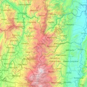
Name: Caldas topographic map, elevation, terrain.

Location: Caldas, RAP del Agua y la Montaña, Colombia (4.80251 -75.92268 5.78288 -74.62459)

Average elevation: 1,540 m

Minimum elevation: 146 m

Maximum elevation: 5,262 m

Other topographic maps

Click on a map to view its topography, its elevation and its terrain.

Cerro Rico

Colombia > Casanare > Recetor

Average elevation: 1,427 m

Gear up for your next adventure:

🔋Solar Power Bank - Keep your GPS and devices charged during long outdoor trips
👟Sport Hiking Sandals - Breathable footwear for water crossings and camp rest
🧴Sunscreen SPF - Broad-spectrum sunscreen for outdoor activities
🧰Multitool Knife - Compact and versatile tool for outdoor use
🧥Softshell Hiking Jacket - The perfect balance of wind protection and breathability

As an Amazon Associate, this site earns from qualifying purchases at no extra cost to you.