Geolocate

Białystok topographic map

Interactive map

Click on the map to display elevation.

About this map

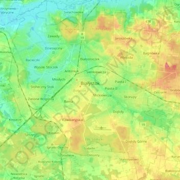
Name: Białystok topographic map, elevation, terrain.

Location: Białystok, Podlaskie Voivodeship, Poland (53.06660 23.06579 53.18860 23.24719)

Average elevation: 142 m

Minimum elevation: 110 m

Maximum elevation: 190 m

The communication system serving the entire city was made of streets radiating out from the central market square. An inventory plan made by Becker in 1799 was needed by the Prussian authorities in connection with the negotiations on the acquisition of Białystok for a royal residence. The plan is of fundamental importance as it shows the development of the city in the first period of its creation. The area of the city did not exceed 1.5 km2, and the population was approx. 3.5 thousand. The entire urban area was closed with 6 loose-fitting gates and buildings situated on regular plots. Compact buildings were found only in the market square, the frontages of which were 1- 2-storey buildings with brick front elevations. Choroska and Zamkowa Streets were built up with only brick houses. The city was dominated by the palace complex, which, together with the park, covered an area equal to the city's investment areas. The residence palace was designed on a European scale and created new development opportunities for Białystok.

Wikipedia (CC-BY-SA 3.0)

Other topographic maps

Click on a map to view its topography, its elevation and its terrain.

Białystok

Poland > Podlaskie Voivodeship

Białystok, Podlaskie Voivodeship, Poland

Average elevation: 140 m

Saki

Poland > Podlaskie Voivodeship > Bielsk County

Saki, gmina Bielsk Podlaski, Bielsk County, Podlaskie Voivodeship, Poland

Average elevation: 137 m

Jelenia Góra

Poland > Podlaskie Voivodeship > Sokółka County

Jelenia Góra, gmina Sokółka, Sokółka County, Podlaskie Voivodeship, Poland

Average elevation: 166 m

Osowiec

Poland > Podlaskie Voivodeship > Zambrów County

Osowiec, gmina Zambrów, Zambrów County, Podlaskie Voivodeship, Poland

Average elevation: 133 m

Augustów County

Poland > Podlaskie Voivodeship

Augustów County, Podlaskie Voivodeship, Poland

Average elevation: 135 m

Sokółka County

Poland > Podlaskie Voivodeship

Sokółka County, Podlaskie Voivodeship, Poland

Average elevation: 153 m

Siemiatycze

Poland > Podlaskie Voivodeship > Siemiatycze

Siemiatycze, powiat siemiatycki, Podlaskie Voivodeship, 17-300, Poland

Average elevation: 149 m

Białystok County

Poland > Podlaskie Voivodeship

Białystok County, Podlaskie Voivodeship, Poland

Average elevation: 152 m

Krynica

Poland > Podlaskie Voivodeship > Krynica

Krynica, gmina Michałowo, Białystok County, Podlaskie Voivodeship, Poland

Average elevation: 152 m

Grodzisk

Poland > Podlaskie Voivodeship > Grodzisk

Grodzisk, gmina Grodzisk, powiat siemiatycki, Podlaskie Voivodeship, 17-315, Poland

Average elevation: 159 m

Łomża

Poland > Podlaskie Voivodeship

Łomża, Podlaskie Voivodeship, Poland

Average elevation: 115 m

Karwowo

Poland > Podlaskie Voivodeship > Karwowo

Karwowo, gmina Rajgród, powiat grajewski, Podlaskie Voivodeship, Poland

Average elevation: 128 m

Grodzisk

Poland > Podlaskie Voivodeship > Grodzisk

Grodzisk, gmina Suchowola, powiat sokólski, Podlaskie Voivodeship, Poland

Average elevation: 163 m

Harkawicze

Poland > Podlaskie Voivodeship > Harkawicze > Harkawicze

Harkawicze, gmina Szudziałowo, Sokółka County, Podlaskie Voivodeship, Poland

Average elevation: 171 m

Wołkusz

Poland > Podlaskie Voivodeship > Wołkusz > Wołkusz

Wołkusz, gmina Lipsk, Augustów County, Podlaskie Voivodeship, Poland

Average elevation: 116 m

Starowola

Poland > Podlaskie Voivodeship > Starowola

Starowola, gmina Jaświły, powiat moniecki, Podlaskie Voivodeship, Poland

Average elevation: 178 m

Sokółka

Poland > Podlaskie Voivodeship > Sokółka

Sokółka, gmina Sokółka, powiat sokólski, Podlaskie Voivodeship, Poland

Average elevation: 167 m