
Make a donation
Gear up for your next adventure:
As an Amazon Associate, this site earns from qualifying purchases at no extra cost to you.
Kaeo River topographic map
Click on the map to display elevation.
Make a donation
Gear up for your next adventure:
As an Amazon Associate, this site earns from qualifying purchases at no extra cost to you.
About this map
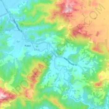
Name: Kaeo River topographic map, elevation, terrain.
Average elevation: 121 m
Minimum elevation: -2 m
Maximum elevation: 386 m
Make a donation
Gear up for your next adventure:
As an Amazon Associate, this site earns from qualifying purchases at no extra cost to you.
Other topographic maps
Click on a map to view its topography, its elevation and its terrain.
Uruti Bay
New Zealand > Northland > Far North District > Bay of Islands-Whangaroa Community
Average elevation: 21 m
Haruru Falls
New Zealand > Northland > Far North District > Bay of Islands-Whangaroa Community > Haruru
Average elevation: 34 m
Waitangi
New Zealand > Northland > Far North District > Bay of Islands-Whangaroa Community
Average elevation: 15 m
Rawhiti
New Zealand > Northland > Far North District > Bay of Islands-Whangaroa Community
Average elevation: 45 m
Make a donation
Gear up for your next adventure:
As an Amazon Associate, this site earns from qualifying purchases at no extra cost to you.
Matangirau
New Zealand > Northland > Far North District > Bay of Islands-Whangaroa Community
Average elevation: 16 m
Taumarere
New Zealand > Northland > Far North District > Bay of Islands-Whangaroa Community > Kawakawa
Average elevation: 53 m
Kaeo
New Zealand > Northland > Far North District > Bay of Islands-Whangaroa Community
Average elevation: 75 m
Onewhero Bay
New Zealand > Northland > Far North District > Bay of Islands-Whangaroa Community
Average elevation: 18 m
Make a donation
Gear up for your next adventure:
As an Amazon Associate, this site earns from qualifying purchases at no extra cost to you.