
Make a donation
Gear up for your next adventure:
As an Amazon Associate, this site earns from qualifying purchases at no extra cost to you.
Capodimonte topographic map
Click on the map to display elevation.
Make a donation
Gear up for your next adventure:
As an Amazon Associate, this site earns from qualifying purchases at no extra cost to you.
Capodimonte
Capodimonte liegt 103 km nordwestlich von Rom und 26 km nordwestlich von Viterbo. Das mittelalterliche Ortszentrum liegt auf einer Höhe von 334 m auf einer Landzunge 15 m über dem Wasserspiegel des ehemaligen Vulkansees. Zum Gemeindegebiet gehört die Isola Bisentina. Capodimonte mit seiner zwei Kilometer langen Promenade entlang des schwarzen, vulkanischen Sandstrands ist im Sommer ein beliebtes Naherholungsziel für Römer.
Make a donation
Gear up for your next adventure:
As an Amazon Associate, this site earns from qualifying purchases at no extra cost to you.
About this map
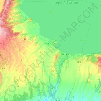
Name: Capodimonte topographic map, elevation, terrain.
Location: Capodimonte, Viterbo, Latium, Italien (42.48099 11.83649 42.59526 11.95179)
Average elevation: 342 m
Minimum elevation: 255 m
Maximum elevation: 524 m
Make a donation
Gear up for your next adventure:
As an Amazon Associate, this site earns from qualifying purchases at no extra cost to you.
Other topographic maps
Click on a map to view its topography, its elevation and its terrain.
Make a donation
Gear up for your next adventure:
As an Amazon Associate, this site earns from qualifying purchases at no extra cost to you.