
Make a donation
Gear up for your next adventure:
As an Amazon Associate, this site earns from qualifying purchases at no extra cost to you.
Ionian Islands topographic map
Click on the map to display elevation.
Make a donation
Gear up for your next adventure:
As an Amazon Associate, this site earns from qualifying purchases at no extra cost to you.
About this map
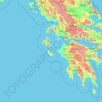
Name: Ionian Islands topographic map, elevation, terrain.
Average elevation: 160 m
Minimum elevation: -5 m
Maximum elevation: 2,393 m
Make a donation
Gear up for your next adventure:
As an Amazon Associate, this site earns from qualifying purchases at no extra cost to you.
Other topographic maps
Click on a map to view its topography, its elevation and its terrain.
Nafplio
Greece > Peloponnese, Western Greece and the Ionian > Argolis Regional Unit > Municipal Unit of Nafplio
Average elevation: 36 m
Chouni
Greece > Peloponnese, Western Greece and the Ionian > Aetolia-Acarnania Regional Unit > Municipal Unit of Parakampylia
Average elevation: 662 m
Nafpaktos
Greece > Peloponnese, Western Greece and the Ionian > Aetolia-Acarnania Regional Unit > Municipal Unit of Nafpaktos > Nafpaktos
Today the population is about 19,768 people according to the 2011 census. Residential homes align with the Gulf of Corinth over a length of about 3 km (2 mi) and a width of about 1 km (0.6 mi). The port divides the beachfront in two parts. The Western part is called Psani, while the Eastern part Gribovo.…
Average elevation: 130 m
Dimitsana
Greece > Peloponnese, Western Greece and the Ionian > Arcadia Regional Unit > Municipal Unit of Dimitsana
Dimitsana is built on a mountain slope at an elevation of 950 meters. From its southern side a marvelous view of Megalopolis plain and Taygetus is provided. Dimitsana is located 53 km east of Pyrgos, 31 km northwest of Tripoli, 23 km northwest of Megalopoli and 17 km northeast of Andritsaina. The village has a…
Average elevation: 1,025 m
Make a donation
Gear up for your next adventure:
As an Amazon Associate, this site earns from qualifying purchases at no extra cost to you.
Argos
Greece > Peloponnese, Western Greece and the Ionian > Argolis Regional Unit
Average elevation: 322 m
Πελεή
Greece > Peloponnese, Western Greece and the Ionian > Argolis Regional Unit > Municipal Unit of Kranidi > Πελεή
Average elevation: 466 m
Xi
Greece > Peloponnese, Western Greece and the Ionian > Kefallonia Regional Unit > Paliki Municipal Unit
Average elevation: 14 m
Zacharo
Greece > Peloponnese, Western Greece and the Ionian > Elis Regional Unit > Zacharo Municipal Unit
Average elevation: 85 m
Make a donation
Gear up for your next adventure:
As an Amazon Associate, this site earns from qualifying purchases at no extra cost to you.