Geolocate

Vallejo topographic map

Click on the map to display elevation.

About this map

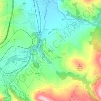
Name: Vallejo topographic map, elevation, terrain.

Location: Vallejo, Silió, Molledo, Cantabria, 39438, Spain (43.11743 -4.05271 43.15743 -4.01271)

Average elevation: 347 m

Minimum elevation: 210 m

Maximum elevation: 620 m

Gear up for your next adventure:

🧴Outdoor Sunscreen - High SPF protection for high-altitude UV exposure
🚲Bike Repair Kit - Essential tools for on-trail mechanical issues
🥾Waterproof Hiking Boots - Essential footwear for rugged terrain and wet Canadian trails
🧴Waterproofing Spray - Restore the DWR coating on jackets and tents
🛏️Sleeping Bag - Warm and compact sleeping bags for outdoor camping

As an Amazon Associate, this site earns from qualifying purchases at no extra cost to you.