
Klayaa topographic map
Interactive map
Click on the map to display elevation.
About this map
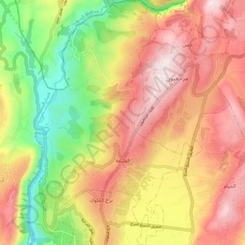
Name: Klayaa topographic map, elevation, terrain.
Location: Klayaa, District de Marjayoun, Gouvernorat de Nabatieh, Liban (33.30968 35.53696 33.38243 35.59191)
Average elevation: 520 m
Minimum elevation: 213 m
Maximum elevation: 784 m
Other topographic maps
Click on a map to view its topography, its elevation and its terrain.
Hasbaya
Liban > Gouvernorat de Nabatieh
Hasbaya, District de Hasbaya, Gouvernorat de Nabatieh, 1704, Liban
Average elevation: 756 m
Marjayoun
Liban > Gouvernorat de Nabatieh
Marjayoun, District de Marjayoun, Gouvernorat de Nabatieh, 1701, Liban
Average elevation: 651 m
Nabatieh
Liban > Gouvernorat de Nabatieh
Nabatieh, District de Nabatieh, Gouvernorat de Nabatieh, 1700, Liban
Average elevation: 469 m
Khiam
Liban > Gouvernorat de Nabatieh
Khiam, Khiyam, District de Marjayoun, Gouvernorat de Nabatieh, 1701, Liban
Average elevation: 577 m