Geolocate

Yuksom topographic map

Click on the map to display elevation.

About this map

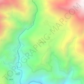
Name: Yuksom topographic map, elevation, terrain.

Location: Yuksom, Gyalshing, Gyalshing District, Sikkim, India (27.34924 88.19848 27.38924 88.23848)

Average elevation: 1,728 m

Minimum elevation: 985 m

Maximum elevation: 2,810 m

Gear up for your next adventure:

💧Hydration Pack - Hands-free hydration system for long hikes
🦟Insect Repellent - Keep mosquitoes and black flies away in wooded areas
💡Compact LED Flashlight - Powerful and portable flashlight for outdoor use
Tent Footprint - Protect tent floor and increase durability
🧴Bear Spray Holster - Quick-access carry for essential Canadian wilderness safety

As an Amazon Associate, this site earns from qualifying purchases at no extra cost to you.