Geolocate

Grebona topographic map

Click on the map to display elevation.

About this map

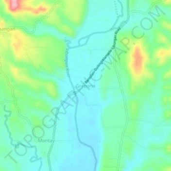
Name: Grebona topographic map, elevation, terrain.

Location: Grebona, Libungan, North Cotabato, Soccsksargen, Philippines (7.27892 124.53955 7.31892 124.57955)

Average elevation: 72 m

Minimum elevation: 35 m

Maximum elevation: 180 m

Other topographic maps

Click on a map to view its topography, its elevation and its terrain.

Libungan River

Philippines > North Cotabato > Libungan

Average elevation: 22 m

Gear up for your next adventure:

🩹Compact First Aid Kit - Pre-packed essentials for common trail injuries
🧦Crew Hiking Socks - Comfortable socks for long-distance hikes
🧣Merino Neck Gaiter - Protects against wind, sun, and cold at high altitudes
🧰Emergency Multi-Tool - Compact multi-tool for outdoor survival
🧳Compression Sacks - Maximize space in your backpack by shrinking gear

As an Amazon Associate, this site earns from qualifying purchases at no extra cost to you.