Geolocate

Pawa topographic map

Click on the map to display elevation.

About this map

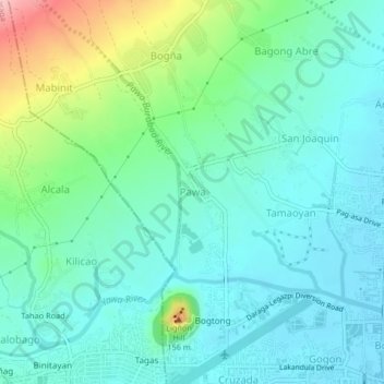
Name: Pawa topographic map, elevation, terrain.

Location: Pawa, Legazpi, Albay, Bicol Region, 4500, Philippines (13.15415 123.71079 13.19415 123.75079)

Average elevation: 46 m

Minimum elevation: 3 m

Maximum elevation: 188 m

Other topographic maps

Click on a map to view its topography, its elevation and its terrain.

Mayon Volcano

Philippines > Albay > Legazpi

Average elevation: 519 m

Sawangan Park

Philippines > Albay > Legazpi

Average elevation: 7 m

Kalayaan Park

Philippines > Albay > Legazpi

Average elevation: 7 m

Gear up for your next adventure:

🧰Emergency Multi-Tool - Compact multi-tool for outdoor survival
🥾Hiking Boots - Sturdy boots providing ankle support and traction on rugged trails
🥾Approach Shoes - Shoes designed for climbing approaches and rugged trails
👟Sport Hiking Sandals - Breathable footwear for water crossings and camp rest
💧Reusable Water Bottle - Durable water bottles for hydration on trails

As an Amazon Associate, this site earns from qualifying purchases at no extra cost to you.