Geolocate

Ciherang topographic map

Click on the map to display elevation.

About this map

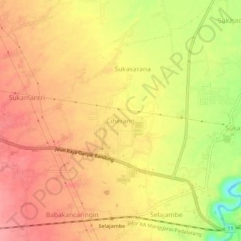
Name: Ciherang topographic map, elevation, terrain.

Location: Ciherang, Cianjur, West Java, Java, 43282, Indonesia (-6.81745 107.20415 -6.77745 107.24415)

Average elevation: 277 m

Minimum elevation: 214 m

Maximum elevation: 309 m

Other topographic maps

Click on a map to view its topography, its elevation and its terrain.

Kertajadi

Indonesia > West Java > Cianjur

Average elevation: 108 m

Agrabinta

Indonesia > West Java > Cianjur

Average elevation: 108 m

Cidaun

Indonesia > West Java > Cianjur

Average elevation: 658 m

Karangwangi

Indonesia > West Java > Cianjur

Average elevation: 119 m

Wanasari

Indonesia > West Java > Cianjur

Average elevation: 31 m

Jayapura

Indonesia > West Java > Cianjur

Average elevation: 73 m

Cisalak

Indonesia > West Java > Cianjur

Average elevation: 49 m

Gear up for your next adventure:

🧣Merino Neck Gaiter - Protects against wind, sun, and cold at high altitudes
🩹Compact First Aid Kit - Pre-packed essentials for common trail injuries
🥘Camping Cookware Set - Compact nesting pots and pans for trail cooking
🧤Thermal Hiking Gloves - Grip-enhanced gloves for cold-weather altitude trekking
🧤Insulated Winter Gloves - Heavy-duty protection for sub-zero Canadian adventures

As an Amazon Associate, this site earns from qualifying purchases at no extra cost to you.