Geolocate

Granger topographic map

Click on the map to display elevation.

About this map

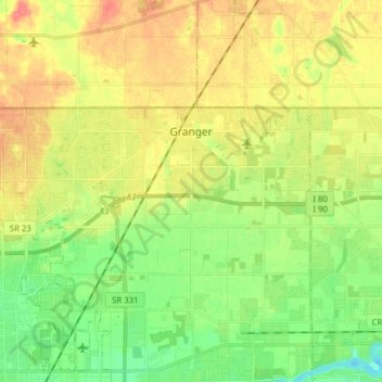
Name: Granger topographic map, elevation, terrain.

Location: Granger, Saint Joseph County, Indiana, United States (41.70957 -86.21754 41.76070 -86.06200)

Average elevation: 239 m

Minimum elevation: 214 m

Maximum elevation: 269 m

Gear up for your next adventure:

🥾Waterproof Hiking Boots - Essential footwear for rugged terrain and wet Canadian trails
🧴First Aid Kit - Essential first aid supplies for outdoor emergencies
🦟Insect Repellent - Keep mosquitoes and black flies away in wooded areas
🏕️Camping Hammock - Integrated protection for sleeping between trees
🧢Sun Protection Cap - Breathable cap to protect from sun exposure

As an Amazon Associate, this site earns from qualifying purchases at no extra cost to you.