
Make a donation
Gear up for your next adventure:
As an Amazon Associate, this site earns from qualifying purchases at no extra cost to you.
Bekenu topographic map
Click on the map to display elevation.
Make a donation
Gear up for your next adventure:
As an Amazon Associate, this site earns from qualifying purchases at no extra cost to you.
About this map
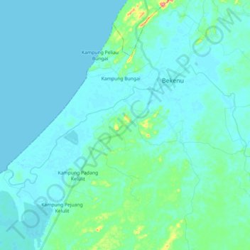
Name: Bekenu topographic map, elevation, terrain.
Average elevation: 11 m
Minimum elevation: -1 m
Maximum elevation: 97 m
Make a donation
Gear up for your next adventure:
As an Amazon Associate, this site earns from qualifying purchases at no extra cost to you.
Other topographic maps
Click on a map to view its topography, its elevation and its terrain.
The Archaeological Heritage of Niah National Park’s Caves Complex
Malaysia > Sarawak > Subis > Batu Niah
Average elevation: 53 m
The Archaeological Heritage of Niah National Park’s Caves Complex
Malaysia > Sarawak > Subis > Batu Niah
Average elevation: 53 m
The Archaeological Heritage of Niah National Park’s Caves Complex
Malaysia > Sarawak > Subis > Batu Niah
Average elevation: 53 m
Make a donation
Gear up for your next adventure:
As an Amazon Associate, this site earns from qualifying purchases at no extra cost to you.