Geolocate

Shivapuri topographic map

Click on the map to display elevation.

About this map

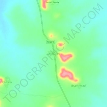
Name: Shivapuri topographic map, elevation, terrain.

Location: Shivapuri, Hadgaon, Nanded, Maharashtra, 431712, India (19.31452 77.61321 19.35452 77.65321)

Average elevation: 446 m

Minimum elevation: 416 m

Maximum elevation: 528 m

Gear up for your next adventure:

🥤Collapsible Travel Cup - Saves space and weight in your mess kit
🧶550 Survival Paracord - Versatile utility cord for emergency repairs and rigging
Camping Coffee Maker - Brew fresh coffee anywhere on the topographic map
🥫Freeze-Dried Meals - Lightweight, high-calorie nutrition for multi-day treks
🩹Compact First Aid Kit - Pre-packed essentials for common trail injuries

As an Amazon Associate, this site earns from qualifying purchases at no extra cost to you.