
Make a donation
Gear up for your next adventure:
As an Amazon Associate, this site earns from qualifying purchases at no extra cost to you.
Yorkana topographic map
Click on the map to display elevation.
Make a donation
Gear up for your next adventure:
As an Amazon Associate, this site earns from qualifying purchases at no extra cost to you.
About this map
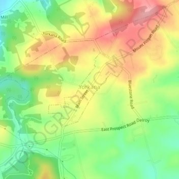
Name: Yorkana topographic map, elevation, terrain.
Location: Yorkana, York County, Pennsylvania, United States (39.97043 -76.59220 39.98179 -76.57743)
Average elevation: 180 m
Minimum elevation: 121 m
Maximum elevation: 242 m
Make a donation
Gear up for your next adventure:
As an Amazon Associate, this site earns from qualifying purchases at no extra cost to you.
Other topographic maps
Click on a map to view its topography, its elevation and its terrain.
Fairview Park
United States > Pennsylvania > York County > Fairview Township > Fairview Park
Average elevation: 187 m
Airville
United States > Pennsylvania > York County > Lower Chanceford Township
Average elevation: 209 m
Make a donation
Gear up for your next adventure:
As an Amazon Associate, this site earns from qualifying purchases at no extra cost to you.
Make a donation
Gear up for your next adventure:
As an Amazon Associate, this site earns from qualifying purchases at no extra cost to you.
Freysville
United States > Pennsylvania > York County > Windsor Township > Freysville
Average elevation: 233 m
Pinchot Lake
United States > Pennsylvania > York County > Warrington Township > Rossville > Alpine
Average elevation: 153 m
Spring Plains
United States > Pennsylvania > York County > Springettsbury Township
Average elevation: 151 m
Make a donation
Gear up for your next adventure:
As an Amazon Associate, this site earns from qualifying purchases at no extra cost to you.
Campbell Estates
United States > Pennsylvania > York County > West Manchester Township
Average elevation: 137 m