Geolocate

Narón topographic map

Click on the map to display elevation.

About this map

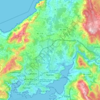
Name: Narón topographic map, elevation, terrain.

Location: Narón, Ferrol, A Coruña, Galicia, Spain (43.48709 -8.25862 43.57806 -8.08483)

Average elevation: 85 m

Minimum elevation: -2 m

Maximum elevation: 357 m

Other topographic maps

Click on a map to view its topography, its elevation and its terrain.

Barallobre

Spain > Galicia > Ferrol > Fene

Average elevation: 50 m

Gear up for your next adventure:

🥾Approach Shoes - Shoes designed for climbing approaches and rugged trails
Camping Coffee Maker - Brew fresh coffee anywhere on the topographic map
🩹Moleskin Blister Pads - Direct protection for painful foot pressure points
💧Reusable Water Bottle - Durable water bottles for hydration on trails
🥾Light Hiking Boots - Lightweight and comfortable boots for day hikes

As an Amazon Associate, this site earns from qualifying purchases at no extra cost to you.