Geolocate

Empire topographic map

Click on the map to display elevation.

About this map

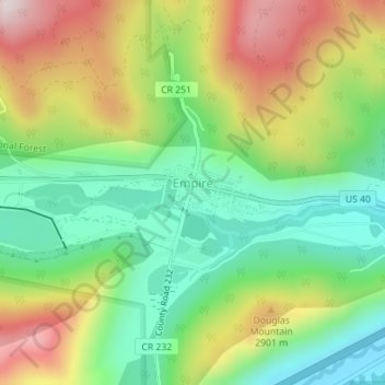
Name: Empire topographic map, elevation, terrain.

Location: Empire, Clear Creek County, Colorado, 80438, United States (39.75540 -105.68910 39.76540 -105.67687)

Average elevation: 2,754 m

Minimum elevation: 2,528 m

Maximum elevation: 3,088 m

Other topographic maps

Click on a map to view its topography, its elevation and its terrain.

Guanella Pass

United States > Colorado > Clear Creek County

Guanella Pass (elevation 11,669 ft or 3,557 m) is a high mountain pass in central Colorado, in the Rocky Mountains of the western United States.

Average elevation: 3,526 m

Alice

United States > Colorado > Clear Creek County

Average elevation: 3,209 m

Goliath Peak

United States > Colorado > Clear Creek County

Average elevation: 3,455 m

Downieville

United States > Colorado > Clear Creek County

Average elevation: 2,713 m

Silver Plume

United States > Colorado > Clear Creek County

Average elevation: 3,106 m

Gear up for your next adventure:

Backpacking Tent - Lightweight tent for long-distance hiking trips
🥾Waterproof Trail Shoes - Shoes designed to handle wet terrain
🥾Mountain Hiking Boots - High-traction boots for rocky terrain
🥾Trail Hiking Socks - Comfortable socks to prevent blisters and fatigue
🧴Outdoor Sunscreen - High SPF protection for high-altitude UV exposure

As an Amazon Associate, this site earns from qualifying purchases at no extra cost to you.