Geolocate

Tobgon River topographic map

Click on the map to display elevation.

About this map

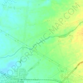
Name: Tobgon River topographic map, elevation, terrain.

Location: Tobgon River, Ligao, Albay, Bicol Region, 4504, Philippines (13.25454 123.54732 13.25519 123.54816)

Average elevation: 55 m

Minimum elevation: 42 m

Maximum elevation: 69 m

Other topographic maps

Click on a map to view its topography, its elevation and its terrain.

Mount Masaraga

Philippines > Albay > Ligao

Average elevation: 752 m

Mount Masaraga

Philippines > Albay > Ligao

Average elevation: 752 m

Gear up for your next adventure:

🚑Survival Whistle - Signal for help across long distances in mountains
🧼Biodegradable Camp Soap - Environmentally friendly cleaning for gear and body
💡LED Headlamp - Hands-free illumination for night hiking and camping
🔋Solar Power Bank - Keep your GPS and devices charged during long outdoor trips
Camping Essentials - All-in-one gear for a comfortable camping trip

As an Amazon Associate, this site earns from qualifying purchases at no extra cost to you.