
Lishui District topographic map
Click on the map to display elevation.
About this map
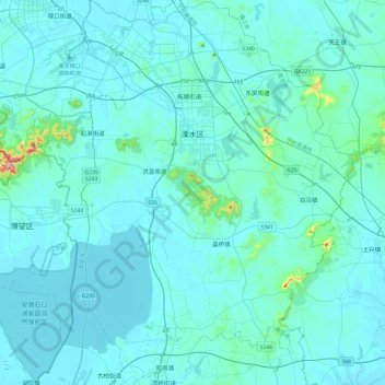
Name: Lishui District topographic map, elevation, terrain.
Location: Lishui District, Nanjing City, Jiangsu, 211200, China (31.38261 118.82815 31.79227 119.23200)
Average elevation: 28 m
Minimum elevation: 2 m
Maximum elevation: 437 m
Other topographic maps
Click on a map to view its topography, its elevation and its terrain.
Nanjing
There are mainly two types of soil in Nanjing: zonal soil and cultivated soil. The zonal soil is yellow-brown soil in the northern and central areas of Nanjing, and red soil in the southern part of the border with Anhui. The cultivated soil formed by man-made farming is mainly paddy soil, and there are some…
Average elevation: 25 m