Geolocate

Andia topographic map

Click on the map to display elevation.

About this map

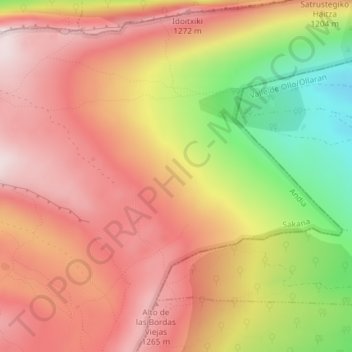
Name: Andia topographic map, elevation, terrain.

Location: Andia, Andía, Sakana, Navarra, España (42.86576 -1.92667 42.88576 -1.90667)

Average elevation: 1,111 m

Minimum elevation: 828 m

Maximum elevation: 1,291 m

Gear up for your next adventure:

🧴Sunscreen SPF - Broad-spectrum sunscreen for outdoor activities
🥾Mountain Hiking Boots - High-traction boots for rocky terrain
🎒Fully Waterproof Backpack - Total protection for photography gear and electronics
🏕️Camping Hammock - Integrated protection for sleeping between trees
🧦Hiking Liner Socks - Thin base layer to prevent friction and blisters

As an Amazon Associate, this site earns from qualifying purchases at no extra cost to you.