
Make a donation
Gear up for your next adventure:
As an Amazon Associate, this site earns from qualifying purchases at no extra cost to you.
Netrokona topographic map
Click on the map to display elevation.
Make a donation
Gear up for your next adventure:
As an Amazon Associate, this site earns from qualifying purchases at no extra cost to you.
About this map
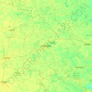
Name: Netrokona topographic map, elevation, terrain.
Location: Netrokona, Netrokona District, Mymensingh Division, Bangladesh (24.72557 90.57324 25.04557 90.89324)
Average elevation: 10 m
Minimum elevation: 1 m
Maximum elevation: 16 m
Make a donation
Gear up for your next adventure:
As an Amazon Associate, this site earns from qualifying purchases at no extra cost to you.
Other topographic maps
Click on a map to view its topography, its elevation and its terrain.
Brahmaputra River
Bangladesh > Mymensingh Division > Jamalpur Sadar Upazila > Jamalpur
The course of the Brahmaputra River has changed drastically in the past two and a half centuries, moving its river course westwards for a distance of about 80 km (50 mi), leaving its old river course, appropriately named the old Brahmaputra river, behind. In the past, the floodplain of the old river course had…
Average elevation: 18 m