
Make a donation
Gear up for your next adventure:
As an Amazon Associate, this site earns from qualifying purchases at no extra cost to you.
Nienburg/Weser topographic map
Click on the map to display elevation.
Make a donation
Gear up for your next adventure:
As an Amazon Associate, this site earns from qualifying purchases at no extra cost to you.
Nienburg/Weser
Die Stadt Nienburg liegt an der Weser in der Norddeutschen Tiefebene in der Mittelweserregion. Die Landschaft ist geprägt durch das Weserurstromtal und die angrenzenden Geest- und Moorbereiche. Die Höhe beträgt 25 m ü. NHN. Bei Nienburg mündet die Große Aue in die Mittelweser. Sie entwässert das Gebiet des westlichen Landkreis Minden-Lübbecke bis westlich der Stadt Nienburg vom Wiehengebirge her.
Make a donation
Gear up for your next adventure:
As an Amazon Associate, this site earns from qualifying purchases at no extra cost to you.
About this map
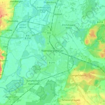
Name: Nienburg/Weser topographic map, elevation, terrain.
Average elevation: 31 m
Minimum elevation: 17 m
Maximum elevation: 76 m
Make a donation
Gear up for your next adventure:
As an Amazon Associate, this site earns from qualifying purchases at no extra cost to you.
Other topographic maps
Click on a map to view its topography, its elevation and its terrain.
Pennigsehl
Deutschland > Niedersachsen > Landkreis Nienburg/Weser > Pennigsehl > Pennigsehl
Average elevation: 54 m
Make a donation
Gear up for your next adventure:
As an Amazon Associate, this site earns from qualifying purchases at no extra cost to you.
Make a donation
Gear up for your next adventure:
As an Amazon Associate, this site earns from qualifying purchases at no extra cost to you.
Make a donation
Gear up for your next adventure:
As an Amazon Associate, this site earns from qualifying purchases at no extra cost to you.
Haßberger Hauptgraben
Deutschland > Niedersachsen > Landkreis Nienburg/Weser > Gandesbergen
Average elevation: 22 m