Geolocate

Sveg topographic map

Click on the map to display elevation.

About this map

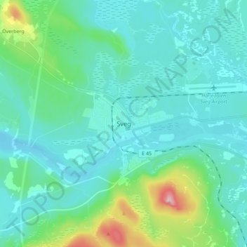
Name: Sveg topographic map, elevation, terrain.

Location: Sveg, Härjedalens kommun, Jämtland County, 842 32, Sweden (61.99607 14.31984 62.07607 14.39984)

Average elevation: 380 m

Minimum elevation: 345 m

Maximum elevation: 558 m

Gear up for your next adventure:

💧Hydration Pack - Hands-free hydration system for long hikes
🥾Trail Running Shoes - Lightweight and durable shoes for trail running
💧Reusable Water Bottle - Durable water bottles for hydration on trails
🧥Insulated Jacket - Keep warm in cold outdoor conditions
Camping Groundsheet - Protect your tent from moisture and dirt

As an Amazon Associate, this site earns from qualifying purchases at no extra cost to you.