
Thank you for supporting this site ❤️
Make a donation
Make a donation
Gear up for your next adventure:
As an Amazon Associate, this site earns from qualifying purchases at no extra cost to you.
Frieira topographic map
Click on the map to display elevation.
Thank you for supporting this site ❤️
Make a donation
Make a donation
Gear up for your next adventure:
As an Amazon Associate, this site earns from qualifying purchases at no extra cost to you.
About this map
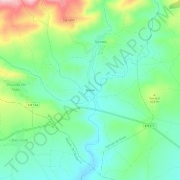
Name: Frieira topographic map, elevation, terrain.
Location: Frieira, Macedo do Mato, Bragance, 5300-613, Portugal (41.55585 -6.78003 41.59585 -6.74003)
Average elevation: 628 m
Minimum elevation: 555 m
Maximum elevation: 792 m
Thank you for supporting this site ❤️
Make a donation
Make a donation
Gear up for your next adventure:
As an Amazon Associate, this site earns from qualifying purchases at no extra cost to you.