
Make a donation
Gear up for your next adventure:
As an Amazon Associate, this site earns from qualifying purchases at no extra cost to you.
Mantua Township topographic map
Click on the map to display elevation.
Make a donation
Gear up for your next adventure:
As an Amazon Associate, this site earns from qualifying purchases at no extra cost to you.
About this map
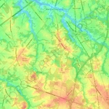
Name: Mantua Township topographic map, elevation, terrain.
Average elevation: 27 m
Minimum elevation: -1 m
Maximum elevation: 56 m
Make a donation
Gear up for your next adventure:
As an Amazon Associate, this site earns from qualifying purchases at no extra cost to you.
Other topographic maps
Click on a map to view its topography, its elevation and its terrain.
Lincoln
United States > New Jersey > Gloucester County > South Harrison Township
Average elevation: 37 m
Creesville
United States > New Jersey > Gloucester County > Washington Township
Average elevation: 32 m
Woolwich Township
United States > New Jersey > Gloucester County > Woolwich Township
Average elevation: 23 m
Make a donation
Gear up for your next adventure:
As an Amazon Associate, this site earns from qualifying purchases at no extra cost to you.
Parkville
United States > New Jersey > Gloucester County > West Deptford Township
Average elevation: 14 m
Mantua Grove
United States > New Jersey > Gloucester County > West Deptford Township
Average elevation: 11 m
Mount Royal
United States > New Jersey > Gloucester County > East Greenwich Township
Average elevation: 11 m
North Woodbury
United States > New Jersey > Gloucester County > Deptford Township
Average elevation: 9 m
Make a donation
Gear up for your next adventure:
As an Amazon Associate, this site earns from qualifying purchases at no extra cost to you.
Jericho
United States > New Jersey > Gloucester County > Deptford Township > Deptford > Jericho
Average elevation: 20 m
Creesville
United States > New Jersey > Gloucester County > Washington Township > Creesville
Average elevation: 32 m
Wolfert
United States > New Jersey > Gloucester County > East Greenwich Township
Average elevation: 15 m
Make a donation
Gear up for your next adventure:
As an Amazon Associate, this site earns from qualifying purchases at no extra cost to you.