Geolocate

Ngadas topographic map

Click on the map to display elevation.

About this map

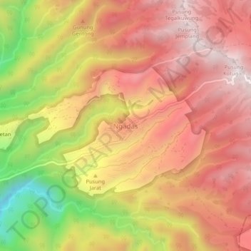
Name: Ngadas topographic map, elevation, terrain.

Location: Ngadas, Kabupaten Malang, East Java, Java, Indonesia (-8.00259 112.88757 -7.96259 112.92757)

Average elevation: 2,050 m

Minimum elevation: 1,538 m

Maximum elevation: 2,362 m

Other topographic maps

Click on a map to view its topography, its elevation and its terrain.

Tegalsari

Indonesia > East Java > Kabupaten Malang

Average elevation: 317 m

Pulau Sempu

Indonesia > East Java > Kabupaten Malang

Average elevation: 26 m

Pulau Sempu

Indonesia > East Java > Kabupaten Malang

Average elevation: 26 m

Gear up for your next adventure:

🥾Waterproof Trail Shoes - Shoes designed to handle wet terrain
🥫Freeze-Dried Meals - Lightweight, high-calorie nutrition for multi-day treks
🧢Hiking Hat - Sun-protective and breathable hats for long treks
🔦LED Flashlight - Powerful and long-lasting flashlight for camping and emergencies
🛰️Satellite Messenger - Emergency communication for areas with no cell service

As an Amazon Associate, this site earns from qualifying purchases at no extra cost to you.