Geolocate

Dragan topographic map

Click on the map to display elevation.

About this map

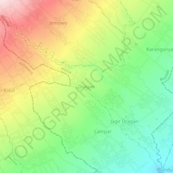
Name: Dragan topographic map, elevation, terrain.

Location: Dragan, Musuk, Boyolali, Central Java, Java, 57483, Indonesia (-7.62563 110.50720 -7.58563 110.54720)

Average elevation: 569 m

Minimum elevation: 420 m

Maximum elevation: 772 m

Other topographic maps

Click on a map to view its topography, its elevation and its terrain.

Selo

Indonesia > Central Java > Boyolali

Average elevation: 1,442 m

Kecamatan Ngemplak

Indonesia > Central Java > Boyolali

Average elevation: 126 m

Jrakah

Indonesia > Central Java > Boyolali

Average elevation: 1,569 m

Klakah

Indonesia > Central Java > Boyolali

Average elevation: 1,237 m

Lencoh

Indonesia > Central Java > Boyolali

Average elevation: 1,672 m

Musuk

Indonesia > Central Java > Boyolali

Average elevation: 718 m

Gear up for your next adventure:

🧴Waterproofing Spray - Restore the DWR coating on jackets and tents
🥾Trekking Boots - Durable boots for long-distance trekking
🔨Vehicle Emergency Tool - Safety tool for remote road trips to trailheads
🥾Hiking Leggings - Comfortable leggings for outdoor activities
🔋Emergency Crank Radio - Weather alerts and power without needing batteries

As an Amazon Associate, this site earns from qualifying purchases at no extra cost to you.